There is plenty you can learn about an area, just by looking at its maps. And no, I am not just talking about locations like the best place to get a bite to eat. I am talking about history. You can really understand the history of a place, when you look at the historic maps that are available to you, and it is all thanks to free public domain data. Public domain data is information that is free for public use, like online maps.
Doing some light examination of the Denver West area (Lakewood, Golden, in Colorado.), the following historic maps and imagery, referenced below, are just two aspects of free public domain data. There is so much more beyond imagery and maps, and even more maps and more imagery (i.e. MODIS, LANDSAT, other NASA products). So if you think you are up to the task, read on, and learn a little more about the Denver West area through its historic maps.
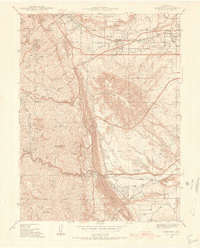
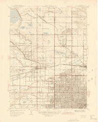
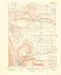
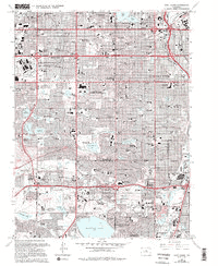
Historic Maps
Below, we see USGS Topo Map that are 1-meter Quads and clockwise:
*Please note that not all maps may download due to firewall or internet-security reasons. For more information, please visit this link.
| Golden – Download – 1939 – 1942 – 1944 – 1957
6 Different dates for 15 Quads 1939-1965 | Arvada – Download – 1941 – 1944 – 1950 – 1957 – 1965
5 Different dates for 12 Quads 1941-1965 |
| Morrison – Download – 1938 –1942– 1947 – 1957 —1965
5 Different dates for 11 Quads 1938-1965 | Fort Logan – Download – 1941 – 1948 – 1957 – 1965
4 Different dates for 8 Quads 1939-1965 |
Historic Imagery
| Historic Imagery type | Year | Metadata | Thumbnail (Actual Files range from 20-200 MB) |
|---|---|---|---|
| Digital Orthophoto Quadrangles (DOQs) | 1994 |
|  |
| National Aerial Photography Program (NAPP) | 1988 |
|  |
| National High Altitude Photography (NHAP) | 1983 |
| Download ~30MB file
|
| Space Acquired Photography | |||
| Single Frame Records Black-and-white, natural color, and color infrared aerial photographs 400 or 1,000 dpi. | 1978 |
|  |
| Aerial Photo Mosaics (Used when creating early/mid-USGS Topo Maps) | 1953 |
| Download the 30MB file
|
| High Resolution OrthoImagery (Corrected – Generally .3 meter, color) | 2002 – HistoricOrthoCoverageAreas.kml | ||
| Declass 1 (1996) Stereo Images | 1965 |
|  |
| Declass 2 (2002) Stereo Images | 1966 |
|

