Will Geoscience Go For A Shared Service Environment?
As a reminder of this subject, our main issue is how we can get geoscience professionals to use shared services for their data services. And there are several problems that impede our attempts. Shared services is the provision of a service by one part of an organization or group, where that service had previously been found, in more than one part of the organization or group. As our previous article, “How can we help geoscience to move their data to shared services” noted, unless we align the stakeholders, get a clear line of sight on their needs, and focus on earning trust and demonstrating value, the answer to the question above is “No.” But let’s say that our client is moving in the direction of shared services. How do we begin to fund and implement this approach?
First Off, The Current Grant And Programmatic Funding Models Are Not Designed To Develop Shared Services Or Interoperable Data For The Geoscience Prefessional
Today there are many geoscientists who are collaborating between disciplines, and as a result improving the quality of knowledge and scaling the impact of their research. It is also well established that the vast majority operate individually or in small teams. Geoscientists, rightly so, continue to be very focused on targeted scientific objectives and not on enabling other scientists. It is a rare case when they have the necessary resources or skills.
Xentity sees opportunities to develop funding strategies to execute collaborative, performance-based, cross-discipline geoscience data solutions. This lack of collaboration has existed since World War II expanded upon its war-time grants to universities. There have been some movement towards hub and spoke (a form of transport topology optimization in which traffic planners organize routes as a series of “spokes” that connect outlying points to a central “hub”) grant-funding models since then, but we are still far away from a more collaborative model.
Also, There Are Few True Shared Services That Are Managed And Extended To The Geoscience Community As Products And Services Should Be
Data-driven science, which is our fourth paradigm of science, has been indirectly “demanding” geoscientific organizations and their systems become 24×7 service delivery providers. We have been demanding IT programmers to become service managers, and geoscientists to become product and data managers. With few exceptions…it has not worked. Geoscientists are still struggling to find and use basic data, produce quality metadata (only 60% meet quality standards per EarthCube studies) for their own purposes, let alone making the big leap to Big data and analytics. Data-driven geoscience requires not only a different business or operating model, but a much clearer definition of the program and the geoscientist’s roles and expectations. It requires new funding strategies, incentive models and a service delivery model underpinned by the best practices of product management and service delivery. Currently, there is no incentive for most geoscientist to think beyond their immediate needs.
Geoscientists Are To Be Encouraged To Increase The Frequency And Volume Of Cross-Discipline Science, There Needs To Be Enablement Services, Interoperable Data And Information Products That Solve Repetitive Problems And Provide Incentive For Participation
We need to develop the necessary incentive and management models to engage and motivate geoscientists, develop a maturity plan for the engineering of shared geoscience services and develop resourcing strategies to support its execution.
The Concept Of Shareable Geoscience Data, Information Products And Commodity Or Analytical Computing Services Has An Existing Operating Precedent In The IT Domain And –shared Services
Shared services could act as a major incentive for participation by the geoscience professional. An approach would identify the most valuable cross-cutting needs, based on community stakeholder input. The team would use this information to develop a demand-driven plan for shared service planning and investment. As an example, a service-based commodity computing platform can be developed to support both the Big Head and Long Tail and act as incentive to participation and perform highly repetitive data exchange operations. Which brings us to the next subject in this: building and sustaining a community like geoscience on shared services.
How Does One Build And Sustain A Community As Large And Diverse As The Geosciences?
The ecosystem of geoscience is very complex from a geographic, discipline and skill level point of view. How does one engage such a diverse community in a sustainable manner? Some solutions include an “increased visibility of stakeholder interests will accelerate stakeholder dialogue and alignment.” Also, “a – avoiding ‘dead ends’ and pursuing opportunities.” The stakeholders can range from youthful STEM to old-school emeritus researchers; from high volume high frequency data producers of macro scale data to a single scientist with a geographically targeted research topic. It is estimated that between 80-85% of the science is done in small projects. That is an enormous intellectual resource that can be made more valuable and productive.
Here is a draft target value chain:
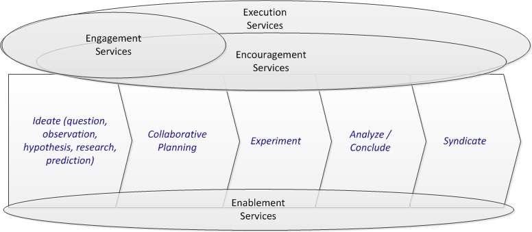
The change or shift puts a large emphasis on upfront collaborative idea generation, team building, and knowledge sharing via syndication, and new forms of work decomposition in the context of crowd participation (Citizen Science and STEM). The recommended change in the value chain begins to accommodate the future needs of the community. However, the value chain becomes actionable based on the capabilities associated to the respective steps. Xentity has taken the liberty to alliteratively define these four classes of capabilities or capability clusters as:
Encouragement, Engagement, Enablement, and Execution.
Encouragement
Capabilities are designed to incentivize or motivate the scientist and data suppliers to participate in the community and garner their trust. They are designed to increase collaboration, the quality and value of idea generation and will have a strong network and community building multiplier effect.
| Questions | Capabilities |
|
|
Engagement Capabilities
Include the geoscience participant outreach and communication capabilities required to build and maintain the respective communities within the geoscience areas. These are the services that will provide the community the ability to discuss and resolve where the most valued changes will occur within the geosciences community.
| Questions | Capabilities |
|
|
Enablement
Capabilities are technical and infrastructure services designed to eliminate acquisition, data processing and computing obstacles and save scientist time and resources. They are designed to solve frequently recurring problems that affect a number of geoscience stakeholders from focusing on their core competencies. Enablement services will have a strong cost avoidance multiplier effect for the community on the whole if implemented and supported.
| Questions | Capabilities |
|
|
Execution Capabilities
These are comprised of the key management oriented disciplines that are required to support shared infrastructure, services or to help evolve a highly federated set of valuable assets “edges” to be more valuable to the evolving community over time.
| Questions | Capabilities |
|
|
So, Why Did We Develop These Classes Of Capabilities?
At the macro level, they represent a way to organize a much larger group of business, operating and technical services that have been explicitly discussed in NSF EarthCube efforts over the last 3-4 years. We then derive these outputs from analysis and associate them to the most important business drivers.
Check out this “draft” relationship of capabilities drivers and rational
| Rationale | Drivers | |
| Engage | The best way to create communities and identify common needs and objectives, begin to build trust and value awareness; bring the respective communities into an environment where they can build out their efforts and sustain collaborative approaches. | Agency (how to navigate planned versus emergent change), intellectual property rights, infrastructure winners and losers, agreement on data storage, preservation, curation policies and procedures, incentives to share data and data sharing policies, and trust between data generators and data users. |
| Encourage | The best models to incentivize scientist’s and data producers to participate and collaborate. Xentity have developed game theory based approaches and large scale customer relationship management solutions | Social and cultural challenges: Motivations and incentives, self-selected or closely-held leadership, levels of participation, types of organizations, and collaboration among domain and IT specialists) |
| Enable | The most costly data processing obstacles – The lowest common denominator – highest impact problem. A common problem found in shared service environments. We have developed enterprise service analysis tools for cost benefit for the DOI geospatial community, so we have seen this work | 80% of scientist data needs can be expressed as standard data product, and 80 % of scientist time is spent getting data into proper form for research analysis |
| Execute | A governance model that will increase the “edge effect” between the legacy and future capabilities and a very diverse set of communities. Simple planning capabilities that empower scientist to work complex cross disciplines ideas amongst themselves, define work and coordinate with the power of the crowd. We have designed collaborative environments and crowd based frameworks for data collection and analysis with corresponding performance management system. | Conceptual and procedural challenges: Time (short-term funding decisions versus the long-term time-scale needed for infrastructures to grow); Scale (choices between worldwide interoperability and local optimization); |
So Why Don’t We Do It?
Well, this introduces an outside approach into a closed knit geoscience community. This community typically solves problems for themselves. Having a facilitated method from outside consulting or even teaming with agency operations who have begun moving this route for their national geospatial data assets is not seen as something fits their culture. We are still learning of hybrid ways we can use to collaborate. In doing so, help the geoscientists setup such a framework. But for now, it is still a bit foreign of a concept, and while there is some awareness by the geoscientist community to adopt models that work for other sectors, industries, operational models, the lack of familiarity is causing a lot of hesitation, which goes back to the earn trust factor and finding ways to demonstrate value.
But, we will keep plugging away, connecting with the geoscience community in hopes that we can help them advance their infrastructure, data, and integration to improve earth science initiatives. As lovers of data, we at Xentity dedicate ourselves to such. Until then, we will remain one of the few top nations without an operational, enterprise national geoscience infrastructure.