

Most of the data that is generated from geoscientists is not intended to be used on larger-scale problems. At least, not used outside of their own specific research or domain. Hence, it can be hard to convince groups in the geoscience field to move their data to “shared services” (I.e. sharing their data as a service to other parts of the organization). And here at Xentity we face a very difficult question in supporting our geoscience clients: How can we help geoscience to move their data to shared services?
First, current grant and programmatic funding models are not designed to develop shared services or not interoperable data for the geosciences. There are very few true shared services that are managed and extended to the community as products and services should be. Also, there is currently limited to no incentive for most geoscientists to think beyond immediate needs. “Furthermore, the culture of collaborative Science is just being established.” Finally, there is no current clear way to build and sustain the large and diverse geosciences community.
There are a lot of problems here, but what about solutions? Well, we believe the solution does not start with the tech, the money, the management, or the governance. Instead, with stakeholder alignment that can be “the extent to which interdependent stakeholder orient and connect with one another to advance their separate and shared interests”.
The Stakeholder Themes We Have Seen In Data Are Generally The Same
These challenges echo the organizing themes of the Xentity supported developments for DOI Geospatial Services Architecture 7 years ago:
- “I know the information exists, but I can’t find it or access it conveniently”, has its analog in “Considerable difficulties exist in finding and accessing data that already exists”
- “I don’t know who else I could be working with or who has the same needs”, has its analog in “Duplication of efforts across directorates and disciplines, disconnect between data and science; data graveyard –useless collection of data…”
- “If I can find it, can I trust it?”, has its analog in “There is a need to evaluate consistency /accuracy of existing data.
For Starters…
To begin the implementation of your solution, you must first develop a clear line of sight to address stakeholder needs and community objectives. This ensures the analysis engages all the necessary dimensions and relationships within the architecture. You need a strategy like this. Otherwise, good solutions, business or technical, often suffer from lack of adoption or have unintended consequences and introduce unwanted constraints.
The cause of these issues is a the lack of alignment. Technology innovators tend to not share the same view of what is beneficial. The same goes for the Geoscientist who typically enable a single or small set of technology directives. We need to create a culture of “shared enterprise” for geoscientists to want to move their data to shared services.
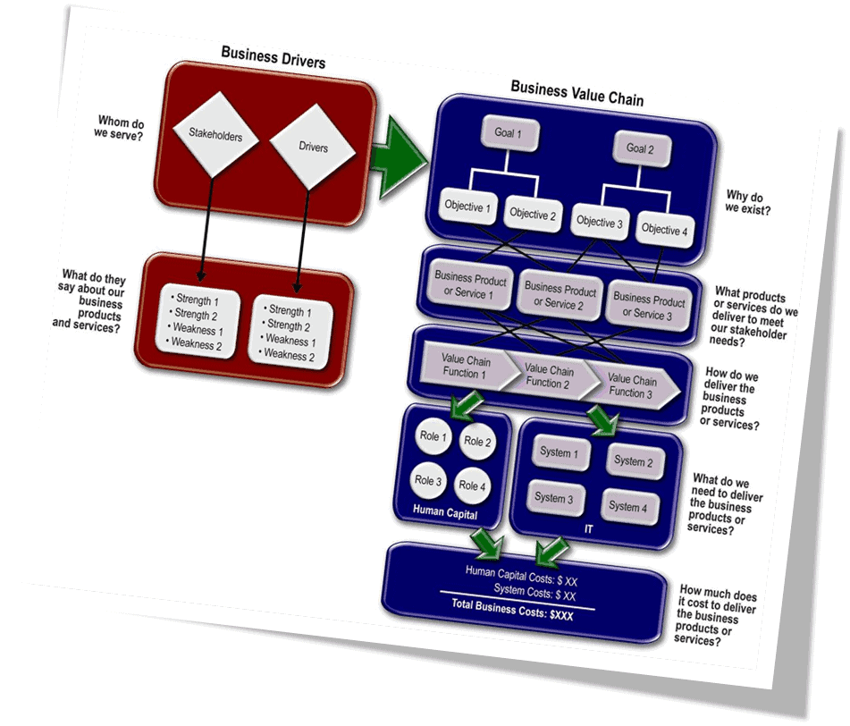
How does one proceed to create the shared enterprise view? By using the “Line of Sight” approach to architecture transformation and analysis. This creates the framework and operating model. It connects business drivers, objectives, stakeholders, products and services, data assets, systems, models, services, components and technologies. Once the linkages have been established, the team will create a conceptual design. This is done by using 40-50 geoscience domain investment areas. This will effectively describe the capabilities of the existing IT portfolio. The architecture and the portfolio will be designed to support governance, future transition planning.
Sample Ecosystem Edge Analysis
To better explain this, take a moment to examine the table below detailing the “edge effects” in the ecosystem. These “edge effects” are changes in population or community structures that occur at the boundary of two or more habitats. They apply to geoscience in a similar manner. There, we see the edge between two different groups or “structures” in geoscience.
| Human Edges (adaptive systems) | Data and Information Edges | Computing and Infrastructure Edges |
| Citizen scientists/ STEM and Professional scientists | Data Supply and Information Product/Services | Centralization and federation of computing infrastructure |
| Geoscience as consumer and producer of data and information | Possessing the data and access the data | Commodity Computing vs. Analytical Computing |
| Individual science and collaborative science | Macro Scale data vs. Micro Scale data | Mission driven systems and shared services access |
| Science Ideation: Piecemeal or segmented vs. holistic | Five data dimensions – spatial (x,y,z), temporal and scale | Domain Systems vs. Interoperability Frameworks |
| Individual vs. Collective Impact and credit | Authoritative sources vs. free for all data | Systems vs. Managed Services |
| Governance rigidity and flexibility | Data and models vs. Product | Big Head and Systematic Data Collection, vs. project components |
| Earth Science and Cyber-infrastructure and Engineering | Long Tail vs. Big Head Data |
So?
The Line of Sight approach allows for exploring the complexities of geoscientist “ecosystem edges”. Also, we can architect for greater interaction and production in the geosciences. Those in the “Long Tail” encounter the same cross domain access, interoperability, management barriers as the “Big Head”. Neither have the incentive to develop common enabling data interoperability services, scalable incentive solutions, common planning approaches or increase the participation of the earth science community. Xentity believes architecture is an enabling design service. This empowers the user community with the tools to expand its capacities. In this case, Xentity will provide the operating model and architecture framework in a conceptual design to bring together the currently unattended edges. In the long run, the models will provide the emerging governance system the tools to develop investments strategies for new and legacy capabilities.
An Operating Model Example: Collaborative Geoscience Planning Could Make A Good Demonstration Case For The Benefits Of The “Edge Effect”
A lot of science efforts are driven by large scale programs or individual research groups who have very little knowledge of who else may be working in the same environmental zones, geographies or even on related topics. A shared planning service could put disparate projects into known time, location and subject contexts and accelerate cross domain project resource savings and develop the resulting interdisciplinary cross pollination required to understand the earth’s systems. An Enterprise geoscience initiative could provide a marketplace for geoscientist to shop around for collaborative opportunities. The plans can be exposed in a marketplace to other resources like citizen scientists or STEM institutions. The work can be decomposed so that environments like Amazon’s Mechanical Turk can post, track and monitor, distributed tasks.
Key Statements
By recognizing these edges, the architecture will create greater value or energy from the disciplines and improve the creativity, strength and diversity of ideas, and mitigate disruption. The ecosystem-like design that balances the Big Head with the Long Tail will enable more cost effective geoscience projects and create a higher return on IT investments while collapsing the time to conduct quality impactful science. Most importantly, this will accelerate the realization of the sciences’ impact on other dependent scientific initiatives or time to develop and implement policy. Xentity sees the potential to use this and other “ecosystem edges” to transform how geoscience is currently conducted.
Xentity believes a geoscientist, emerging (STEM) or emeritus would be willing to participate in cross-cutting, shared service model based on how well these edges are architected and governed. If designed and operated effectively, the edges will create an environment that will address the two key barriers to adoption: trust and value. In essence, we see the scientists as consumers and producers.
- As consumers of data, information and knowledge products and technology services, they are continuously looking to create more knowledge and contribute to social benefit.
- As producers they contribute data, information and knowledge back into their colleagues’ knowledge processes.
In fact, the predominant challenge for such an approach is that the share-service will be developed by the community who themselves are a consumer. Just like any other consumer, they will have expectations when they purchase or use a product or a service. If one cannot uphold the terms and conditions of product quality or a service agreement; you lose the consumer. So, how does the architecture ensure these “edges” develop and evolve? It must ensure:
How To Earn Geoscientists’ Trust
The geoscientist needs to know that they will have highly reliable technical services. They also must know they will have authoritative data that are available and perform well when they request them. Most importantly, they will need to influence and control who and how they conduct the work within the shared environment. They need to ensure the quality of the science and appropriate credit.
How To Demonstrate The Value To The Geoscientist
The geoscientist needs the provider to correct products or services that will eliminate the most significant barriers and constraints to doing more and higher quality science – research, analysis and experimentation – with less effort. In the short term, the shared service challenge is to earn the scientists trust and identify the optimal suite of products and services to provision value from the “community resources” as defined in Layered Architecture. For land elevation products up to 80% of the requests are for standardized products. If done correctly, the governance system, operating model and architecture framework will develop the trust and value recognition from the shared community. In the longer term, the models and framework will guide the redirection of its limited resources towards an interoperable set of systems, processes and data.
The Broader Impact
At its core, we believe the geoscience integration challenge is to exploit the benefits and possibilities of the current and future geoscience “ecosystems edge effect”. In the ecosystem metaphor, the conceptual design approach will target the boundary zones lying between the habitats of the various geoscience disciplines and systems. We require an operating model, architectural framework and governance system that can understand the complexities of a geoscientist shared environment and successfully induce the “edge effect”. It needs to balance the well performing aspects of the existing ecosystem with new “edges” to generate greater dynamism and diversification for all geosciences.
This Is Great And All, But Even If We Create This, How Do We Fund?
See the next part on “Will geoscience go for a shared service environment” which discusses ways to address funding, ways to engage, encourage, enable, and support execution of these enterprise capabilities for geoscientists.