

Kudos to the Canadian Government, particularly, the National Resources Canada (NRCAN), for trying to get a clearer understanding of the economic significance and industry status of geospatial data products, technologies and professional services industry. We live in a time where data is becoming increasingly valuable in an expanded world. Consequently, an inevitable debate rises up on what is more valuable: macro geospatial data, or micro? And how does this kind of data impact the economy? The Boston Consulting Group (BCG) produced a somewhat similar economic impact assessment for the United States in April 2013. http://geospatial.blogs.com/geospatial/2013/04/contribution-of-geospatial-services-to-the-united-states-economy.html
Thoughts From The “Bigots”
We geo-bigots working to support the public sector intuitively and intellectually realize geospatial data’s potential value. And, we are continuously frustrated by our lack of a collective ability and capacity to make its implementation simpler, more immediate, and more powerful. While these macroeconomic concepts are interesting and useful they do not necessarily influence the small-scale government decision making capabilities. The BCG report “cautions that to continue this growth will require sustained public and private-sector cooperation and partnership, open policies governing collection and dissemination of location-based data and increased technical education and training at all level”.
The intent of the US Federal Geographic Data Committee (FGDC) “GeoPlatform” and Canada’s FGP, if supported by the proper data management policies and practices, could simplify the data quality and acquisition challenges resident in our hyper-federated geospatial data environment. Ironically, in the emerging and overwhelming information and knowledge-based economy we are still struggling to manage data content. Geospatial will not become a part of the program and mission operations. At least, not until business leadership fundamentally adopts information centered performance objectives as a part of their organizational culture.
And We Should Care Because…
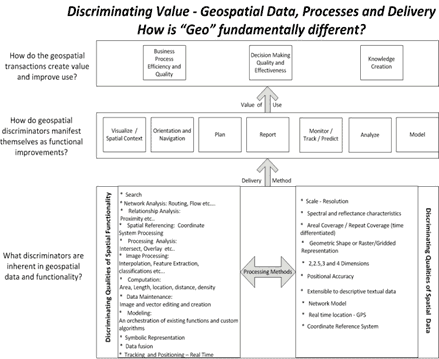
Geospatial has always been an obtuse concept to classify, evaluate or pigeonhole into a nice neat framework. And it gets even tougher to determine its national economic value. For similar reasons, within the US Federal government, “geospatial” has struggled to take an organizational position that would enable its potential value to be maximized. This is partly due to the complexity of its data structure. Which results in its form, resolution, temporal range, scale, geometry or accuracy qualities creating an artificial “boundary”. And now, organizations are having a hard time navigating out of it. This will continue until the “director” sees the “map” or the “picture’.
Here at Xentity, we want to frame the discussion around how to exploit geospatial value at the micro or organizational level. Furthermore, we want to begin to guide our customers to sustained geospatially-driven improvements in their businesses. You can find our initial thoughts on how to break the field down in the diagram. And from there, we ask the question, how can we improve?